
In the fall of 2022 the U.S. Army Corps of Engineers (USACE) released their Draft Integrated Feasibility Report and Tier 1 Environmental Impact Statement as a part of their New York New Jersey Harbor and Tributaries Coastal Storm Risk Management Feasibility Study (HATS) for public review. After analyzing the impact of Hurricane Sandy and the estimated effects of future 100-year storms USACE has selected a proposed plan (Alternative 3B) from 5 proposed options, to protect the HATS region from this future existential threat. Arriving at this preference involved consideration of metrics such as: benefits, negative consequences, development costs, construction time and lifespan. Having a base cost of $52 billion and a construction timeline of 14 years (both roughly in the middle of the 5 alternatives), Alternative 3B includes storm surge protection infrastructure for targeted areas of the HATS region. Newtown Creek is one of the target areas. USACE proposes installing a storm surge barrier and gate across the mouth of the creek near Box Street and connecting tie-in infrastructure (seawalls, floodwalls and levees) along the shorelines of Greenpoint and Hunters Point. However, the Greenpoint tie-in protection ends at Greenpoint Avenue leaving all areas south of that point completely unprotected, including Bushwick Inlet, a source of chronic severe flooding during storm surges and severe rain events.
Your voice is very important. USACE wants input from the ground to best inform their design choices.
Public comment submissions are encouraged. However the deadline for submission is March 31st, 2023. Direct comments to:
Mr. Bryce W. Wisemiller, Project Manager
U.S. Army Corps of Engineers New York District,
Programs & Projects Management, Planning Division
Jacob K. Javits Federal Building, Room 17-401
c/o PSC Mail Center
26 Federal Plaza
New York, New York 10278
nynjharbor.tribstudy@usace.army.mil
A video playback of a town hall convened on February 23, 2023, by Congresswoman Nydia Velazquez including a presentation on the study by USACE, created and posted by North Brooklyn Parks Alliance.
Rebuild by Design extensive teach-in materials.
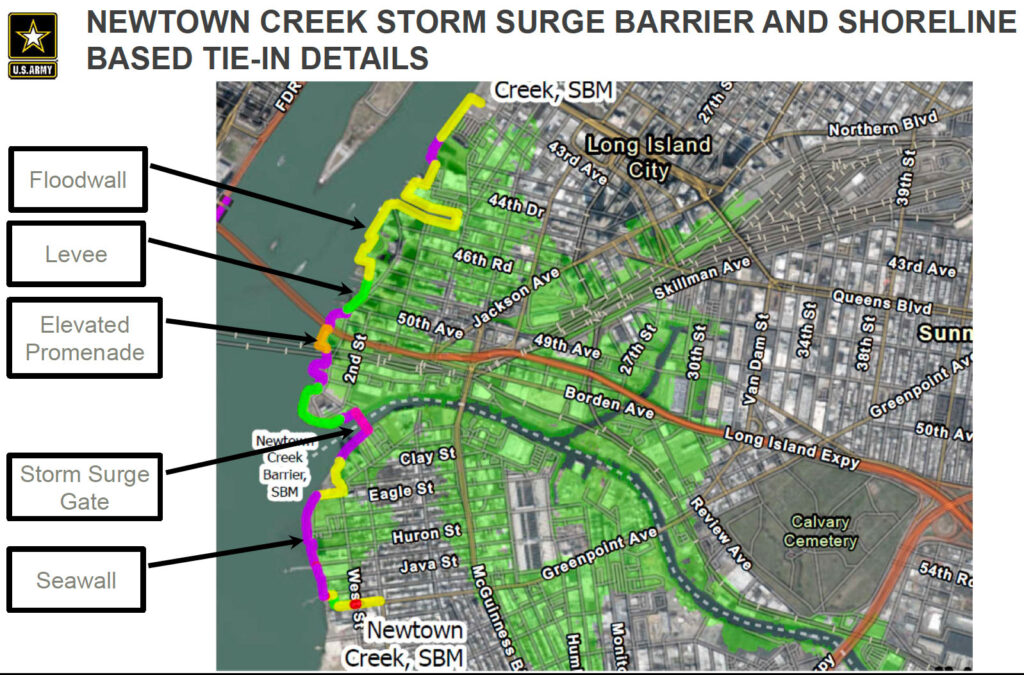
TENTATIVELY SELECTED PLAN FEATURES IN DETAIL Newtown Creek Area Storm surge barrier with shoreline based tie-ins, USACE
Since no “walls” have been recommended by USACE in Alternative 3B for mitigating storm surge risk along Bushwick Inlet Park’s East River and Bushwick Inlet shorelines, we must conceive of innovative ways to calm sources of flooding in this area. The development of the remaining sections of Bushwick Inlet Park can serve as an amazing opportunity to design parkland to be protective against storm surges and adaptive and resilient during cloudburst events, while also being a highly engaging, universally accessible waterfront green space and recreation hub for park goers.
We should focus on measures (including but not exclusively) a multi-layered, multi-tiered waterfront, wetlands, and berms that can serve to calm surges and act as an aggregate passive flood defense. The Fidi & Seaport Coastal Resiliency plan can be inspiration for this design approach. Yanweizhou Park in Jinhua City, China brilliantly utilizes this idea. As does Hunters Point South Park which was designed with a beautiful natural barrier as the prime source of protection while creating an amazing park user experience along the East River and Newtown Creek. Though the northern and southern banks of Bushwick Inlet will be elevated more significantly, the thin strip of land between the inlet and Franklin Street will only rise to approximately 9’. To help calm storm surges from Bushwick Inlet, artificial reefs could be installed inside the inlet and/or just outside it. The Living Breakwaters project being installed off the coast of Staten Island is deploying this strategy that will calm storm surges to a height of just 3’ while enhancing the estuary ecosystem with reefs designed to support marine life. We could also integrate active use areas of the park into the passive flood defense. In 2018 NYCHA and NYC Department of Environmental Protection created the South Jamaica Houses Cloudburst Master Plan 2018. In this area that chronically floods during strong rain events, these agencies and their designers proposed a multi-pronged approach to help mitigate this threat. One of these prongs is to redesign a basketball court to act as a flood basin by depressing the court into the ground to retain floodwater during storms, and then resume its recreational use upon dissipation of floodwater. These are just a small example collection of highly innovative approaches to utilizing a green infrastructure dominated approach to designing protection into public park space, and protecting affected connecting neighborhoods.
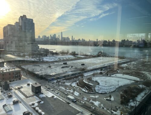
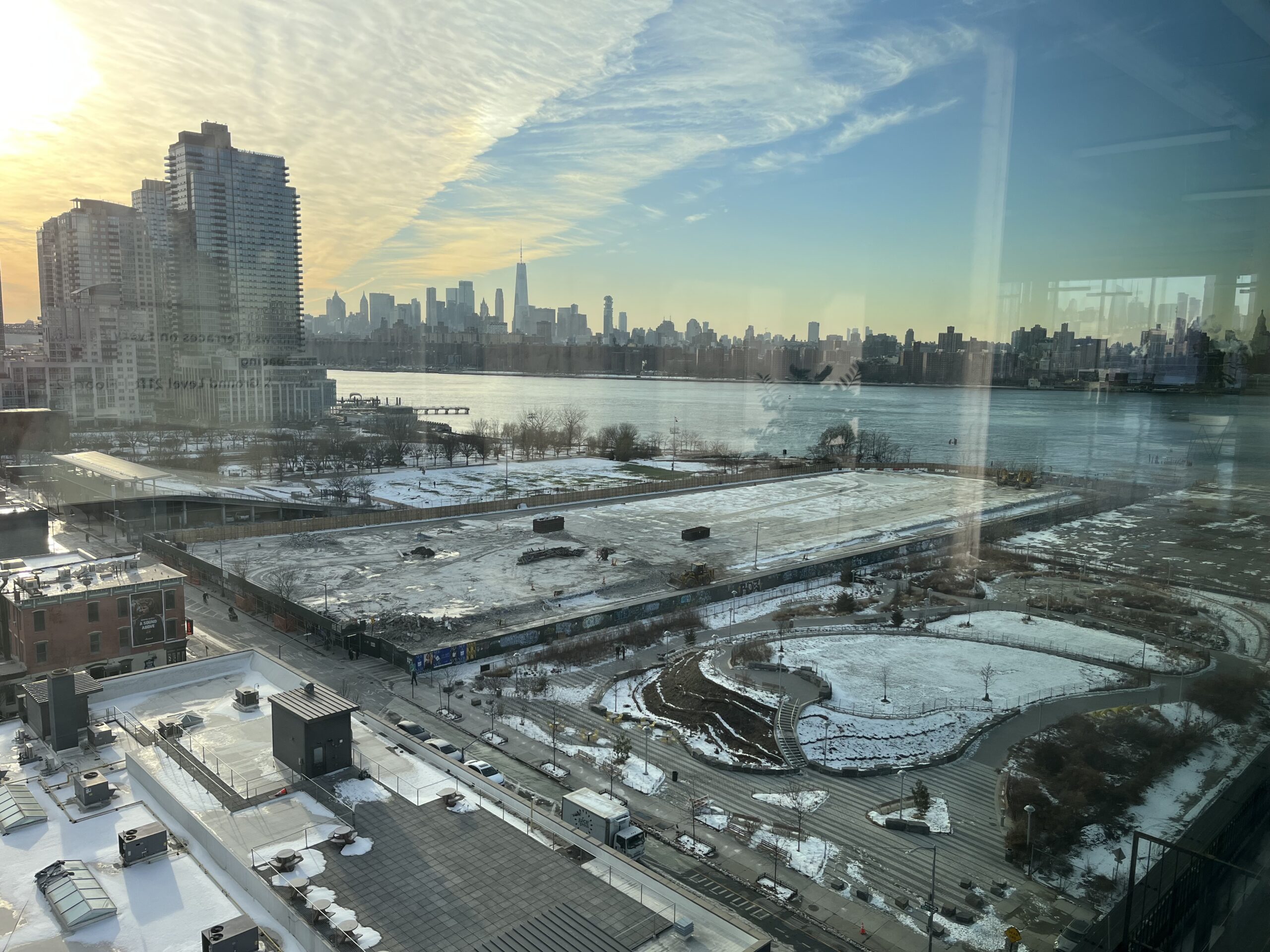
Bushwick Inlet and the connecting East River have the dubious distinction of inducing flooding in McCarren Park and areas adjacent to its southern edge as floodwaters permeate the former footprint of Bushwick Creek. An inspirational measure to mitigate this problem would be to create a green corridor between McCarren and Bushwick Inlet Parks, by reimagining and redesigning the public realm that binds these two spaces by reimagining and redesigning the public realm that binds these two spaces with an abundance of green infrastructure.
A new existential threat emerged in 2021 when the MTA approved a property development plan for their 40 Quay Street property which abuts the northern bank of Bushwick Inlet (and the park in development). Contingent on an upzoning this plan will allow for a private developer to build an enormous 530’ structure made of concrete and steel. Not only would this development impose an incredibly negative impact on Bushwick Inlet and the park, it will make protection against storm surges very difficult to create as has been noted with the USACE designing protection for existing properties with high density building projects along the northern Greenpoint shoreline. A preponderance of hardscape leaves a minimum amount of land from which to create more intricate, softer protective measures. Expanding Bushwick Inlet Park to include this 2-acre parcel from which to design and create nature-based protections is a much stronger methodology, while also adding more park space to an overdeveloped neighborhood that desperately needs it. Federal, state and city investment in creating park-based green infrastructure here will create the true highest and best use of this publicly-owned space.
Another major area of concern is pollution from Combined Sewer Overflow outfalls. The mouth of Bushwick Inlet contains two of them. USACE design plans propose creating drainage for Newtown Creek when the storm surge gate is closed. We are worried that these two CSOs will provide relief for the creek while burdening the inlet and the nearby East River shoreline with additional volume of contaminated wastewater. The NYC Department of Environmental Protection’s Long Term Control Plan which has the goal of significantly reducing CSO outfall into Newtown Creek will also be redirecting outfall to East River CSO outfalls. We urge the USACE to explore other measures to manage wastewater flow other than “robbing Peter to pay Paul”.
The design of Bushwick Inlet Park and adjacent areas is a tremendous opportunity to simultaneously protect the local neighborhood and create a wonderful engaging public park on our waterfront. Protection of the North Brooklyn area from storm surges must be addressed holistically including areas not covered by Alternative 3B and mitigate increasing flooding threats from cloudburst events and rising ground water levels district wide, and the increasing problem of wastewater outfall management. In October of 2022 New York City Mayor Eric Adams called on the federal government to provide $8.5 billion in grant funding to complete critical resiliency projects. Bushwick Inlet Park was named as one of those projects. As many groups and individuals in North Brooklyn call for less severe protective measures in northern Greenpoint, reallocating Alternative 3B funding to design and create layered nature-driven measures along the entire North Brooklyn waterfront including Bushwick Inlet Park, which would effectively upgrade and enhance our Waterfront Open Space Master Plan, will support a just and equitable future for our neighborhood.
Reference images:
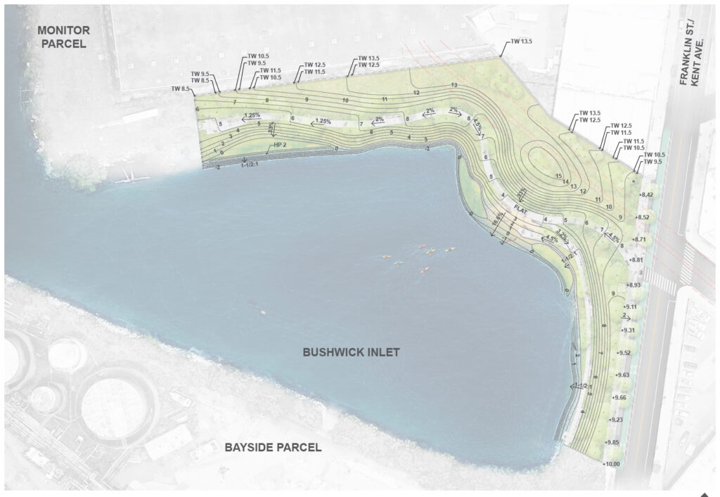
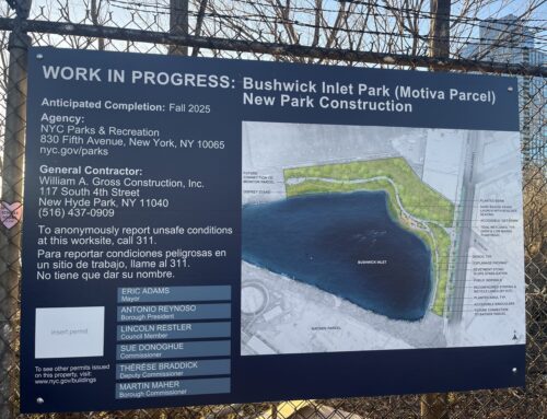
Grading design of Motiva section of Bushwick Inlet Park, NYCDPR, Abel Bainnson Butz
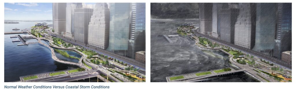
Fidi & Seaport Coastal Resiliency Plan
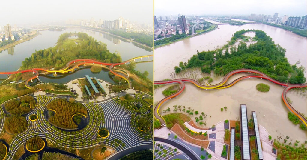
Yanweizhou Park in Jinhua City, China, Turenscape Landscape Architecture

Hunters Point South Park, SWA

Living Breakwaters project, SCAPE Studio

South Jamaica Houses Cloudburst Master Plan 2018, basketball court redesigned as a retention basin.
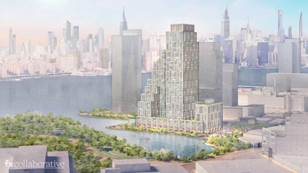
MTA approved Monitor Point development adjacent to Bushwick Inlet.

Alternative design for the MTA site as green open space, Friends of Bushwick Inlet Park

